| race
route | course description
| route
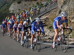
map About the Race: Course Description As in 2004, this year’s race leaves the west coast from the harbor-front starting line in San Diego. After cycling 3,047 miles, climbing over 109,000 feet and crossing fourteen states—as well as all four of the continental United States’ time zones—racers will arrive at the east coast to finish on the Atlantic City’s Historic Boardwalk. Along the way they will be challenged with everything a country as large and diverse as the USA can offer. The solo parade zone leaves downtown San Diego and passes through the world-famous San Diego Zoo before dropping into Mission Valley: the team parade zone heads north along the Pacific Coast Highway instead. Shortly after passing Qualcomm Stadium, the racers turn up few short grades and the official race begins at mile 21. A series of continuous gradual climbs along I-8 frontage roads takes the riders to the 4,000 foot Tecate Summit and the first of 57 time stations at Pine Valley. The terrain gets much drier as the course dips south to within a stone’s throw of the Mexican border before plummeting in the heat haze of the Yuha Desert. North of El Centro, the race dips to its lowest elevation (100 feet below sea level). El Centro is the commercial hub for the agriculturally rich Imperial Valley. If the Santa Ana winds kick up, crossing the Algodones sand dunes will take the racer’s full attention as drifting sands could bury much of the road. At Blythe, the racers cross the Colorado River and depart California. Conditions continue to toughen in Arizona. The route trends upward along I-10 west of Quartzite and along US 60 further east. in Arizona. The barren stretch between Wenden and Gladden will be more mentally demanding than almost any other part of the course: for over twenty miles the road is perfectly straight and not even the string of telephone poles along the left side of the road appears to alter in appearance. The desert is not a forgiving environment. Surviving this, the racers are rewarded with some exceptionally scenic climbing: the legendary Yarnell Grade as well as subsequent climbs into Prescott. Heading north, the racers join I-40 for the fifty easterly miles into Flagstaff. Once again, the route bends north into the Indian Country east of Grand Canyon. At Kayenta the racers pass between the silent sentinels that guard the spectacular Monument Valley. The Utah canyons around Mexican Hat and Bluff wll be equally memorable. Western Colorado brings the Rocky Mountains: the high Rocky Mountains. Between Cortez and Durango, Mancos Mountain and Hesperus Hill are simply polite introductions to the much more significant climbing to follow. Not until the racers pass through Pagosa Springs do things get really serious. Wolf Creek Pass is a true “working man’s” climb: once the road tilts upwards. the 8% grade doesn’t moderate until it crests at the 10,550 foot continental divide. La Veta Pass follows: somewhat less steep but with much more open vistas. Finally, Cuchara Pass completes the trio: a narrow, windy climb that tops out just under 10,000 feet. After coasting down the eastern slopes of the Rockies, the racers emerge into the high plains of eastern Colorado at Trinidad. Tailwinds are likely to push the racers along. Unfortunately, thundershowers and lightning are equally likely to accompany the racers. In Kansas the plains continue their tilt eastward, dropping from 3,000 feet in the west to 1,000 feet in the east. The route passes just south of the wild-west town of Dodge City and the Santa Fe Trail. Towns, along with their water towers, regularly interrupt the continuity of sunflower-lined roads. Halfway across the state, the route leaves US 54 to skirt around the busy Wichita traffic. It is here, soon after crossing the Arkansas River, the racers will be the halfway through the race. At Fort Scott the racers enter Missouri. Immediately, rolling hills and distinctive “lettered” state highways will clue the riders that they aren’t in Kansas any more. Midway across the state, the route crosses two widely separated arms of the massive Lake of the Ozarks and between which the racers will be forced to contend with an overabundance of vacationing motorists. A short while later, riders circle the magnificent rotunda of the state capital at Jefferson City and cross the Missouri River. For the next 70 miles, the road never strays far from the river and is fairly flat, except for two sections of short extremely steep twisty climbs. Finally, a bit north of St. Louis, racers will cycle over the mighty Mississippi on a magnificent golden yellow suspension bridge, The Clark Bridge, into Alton, Illinois. RAAM slices through the farming country of southern Illinois and central Indiana, following US 40 for most of the way. The historic National Road spurs off at several spots—including once to pass through an old covered bridge within sight of the race route. Along the tree-shaded boulevards of Terre Haute, Indiana, the race enters the Eastern Time Zone, to complete the final third segment of the race. (Note: Indiana time zone rules—i.e., “Indiana Time”—are extremely confusing. Like Arizona, most of the state does not observe daylight savings time. For this summer’s race, local time in Indiana is the same as Missouri’s.) Continuing east, RAAM retraces the RAIN (Ride Across Indiana) route, arcing south of Indianapolis and on into Richmond Considering that Ohio is the seventh most populous state, racers will be pleasantly surprised at how rural this section is. The course gently rolls north of Dayton (reaching its northernmost point outside Urbana) before trending southeast, to the west of Columbus. Steep inclines once again challenge the riders through the thirty miles of hardwood forests of the Hocking Hills region. In Athens, the grades moderate as the riders skirt Ohio University’s sprawling campus and athletic fields. RAAM crosses the Ohio River and enters West Virginia on US highway 50 and starts a series of climbs through the Appalachian Mountains. As the road narrows, it climbs over the Eastern Divide at 3,000 feet above sea level, then climbs again to the ominously named Mt. Storm before dropping into Maryland. Some of the most intense grades of the entire race are found on scenic US route 40 in the forty miles between Cumberland and Hancock. The fourth of these climbs, Sideling Hill, subjects riders to a 1,000 foot ascent in two miles. Fortunately, once the route enters Pennsylvania racers will no longer face any extended climbs. Unfortunately, between Gettysburg and the Susquehanna River an interminable series of extremely steep but mercifully short rollers will discourage all but the toughest of competitors. The course then starts to flatten out as it enters Pennsylvania Dutch “horse and buggy” country. After skirting the southern suburbs of Wilmington, Delaware, racers will be shuttled over the Del Mem Bridge over the Delaware River into New Jersey. The increasing traffic hints of the now near and approaching finish line. After one last time station in Mckee City, Atlantic City’s casino-dominated skyline rises in the distance. The racers collect a police escort for their entry into the city. Finally, after crossing the familiar “Monopoly” streets—Atlantic, Pacific—the racers arrive at the Historic Boardwalk, just a few feet short of the Atlantic Ocean. |
|
 |